 |
|||||||
Maps and Charts |
|||||||
| PRICES FOR ALL MAPS AND CHARTS AVAILABLE ON REQUEST | |||||||
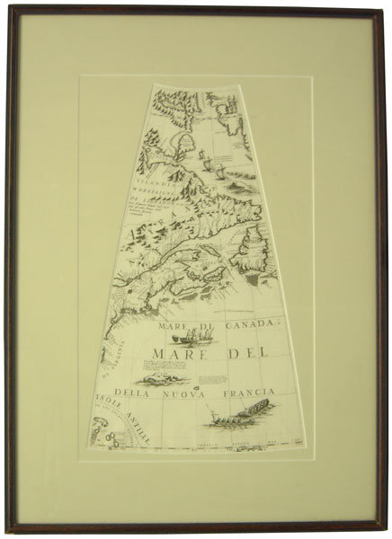
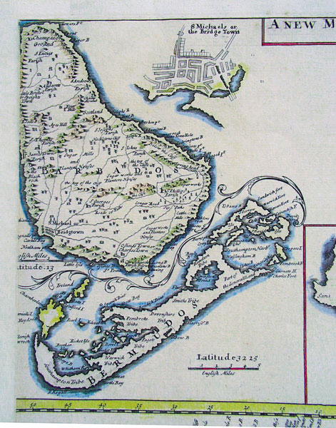
Anon (Atlas Maritimus).
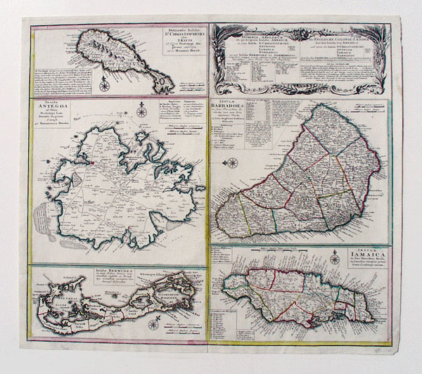
London 1728. A map of Barbados and Bermuda.
9 1/2 x 11 1/2 inches. Rather a strange map with Bermuda
printed upside down and Barbados as Barbadoes. Nathan Cutler was the
actual cartographer and there is in existence another section of map
showing Boston Harbour and Antegoa. Essential bays and forts exist
in the rather stringy Bermuda outline but little is still known of
the full extent of the reef line.
|
|||||||
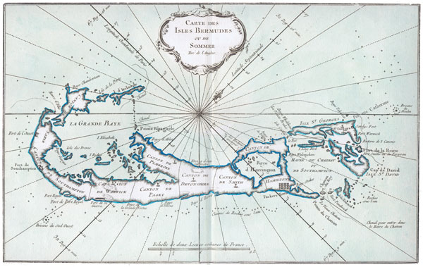
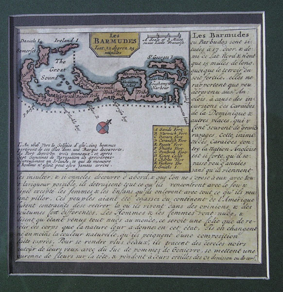
Bellin. Carte des Isles Bermudes. c1763. Outline colour.
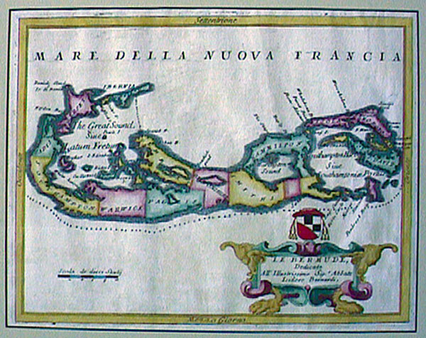
32.5 x 20cm. Printed in Paris for incorporation in the Petit Atlas Francois, the Bellin divides Bermuda into tribes and here calls them cantons. Some of the names given are unusual and the cartouche has a rococco shell like feel to it. |
|||||||
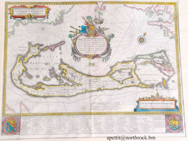
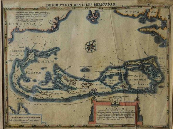
Blaeu. Mappa Aestivarum Insularum. 53x40cms. Original colour. c1635. Printed in Amsterdam, this classic map of Bermuda is complete with the names of the shareholders of the Somers Isles Company underneath, together with details and geographical facts of their holdings. Above, in the cartouche, Neptune holds the ship ‘Sea Venture’ in his hand as he cradles the standard of England topped with a crown. Beneath him is a shield emblazened with mermaid-like creatures holding conchs and supporting their catches of fish. A monster completes the scene. |
|||||||
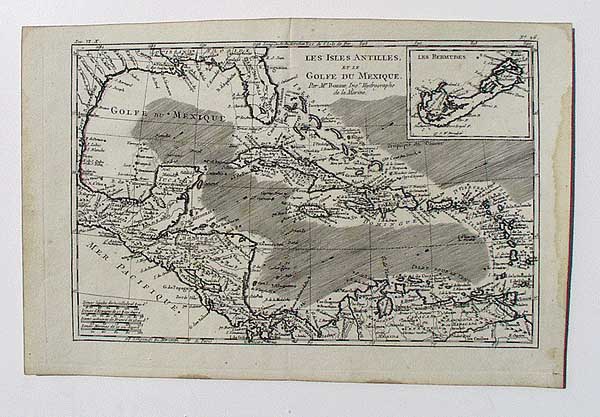
Bonne.Isles
Antilles et le Golfe du Mexique. 32x21cms. c1783. Hand coloured. |
|||||||
Bowen. A
New and Accurate Map of the Bermudas or Sommers Islands. 21.5x35cms. c1747. |
|||||||
Chatelain. Des Isles et Terres que les Anglois possedent (Detail). 51x40cms. Uncoloured. full sheet. |
|||||||
Colton. West Indies. 39.5x32.5cms 1855.Insets of Bermuda and Havana. Original colour. Decorative border. Published by J H Colton &Co, No 172 William St, New York |
|||||||
Coronelli Gore. c1690. Uncoloured.
25.5 x 45cm. |
|||||||
Coronelli. Le
Bermude. 30.5x23.5cms. One of four islands on a very large sheet. Hand coloured.
c1692. |
|||||||
Covens and Mortier.(Detail).
The Bermudas or Summers Islands. Part of a large map 57x52.5cms from Atlas
Nouveau Amstelodami c1757. |
|||||||
Crepy. Bermuda and Jamaica. 26.5x20cms. |
|||||||
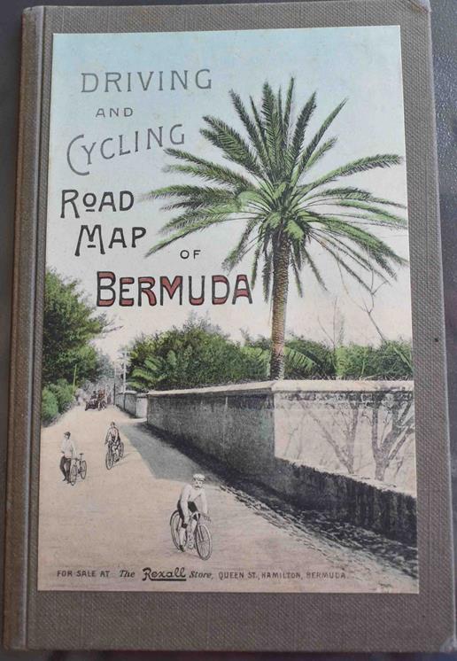
Driving and Cycling Road Map of Bermuda. c.1920. 3 1/2 X 5 1/2 inches.
This
was the age when cycling and walking were the craze on the island.
Bermuda was then regarded as principally a winter resort and
vigorous exercise was encouraged. Road surfaces were graded as best,
good or poor. Hill steep, very steep and dangerous for
wheelies(bikes).
|
|||||||
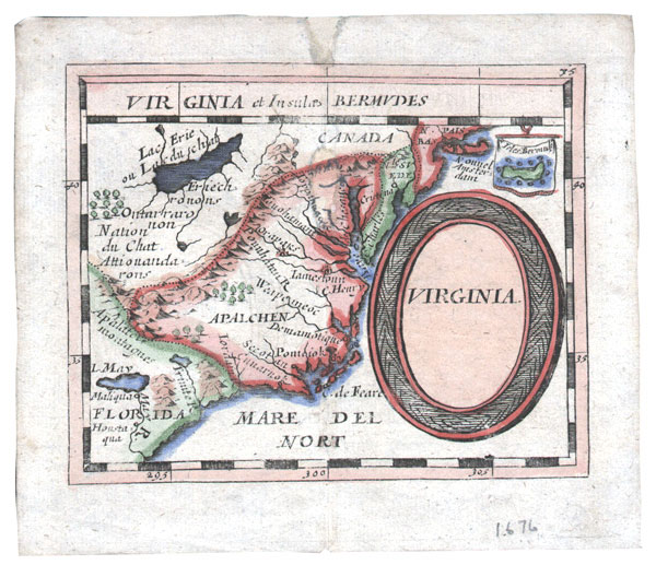
Duval. c1690
5 x 5cms A map of La Virginie from a miniature atlas published in Paris .Scarce. |
|||||||
Fullarton. Bermuda or Somers Islands together with Jamaica. 30.5x45cms. Coloured
lithograph. c1860. |
|||||||
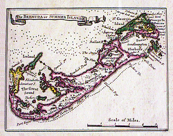
Gentleman’s Magazine. Bermuda or Summer Islands. 18.5x23.5cms. Outline colour. c1763. |
|||||||
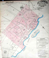
Goad, Chas E. Civil Engineers. Fire Plan of St Georges, Bermuda. Mar 1897. Original Colour. 25 x 22 inches. |
|||||||
Homann Heirs. Die Englische Colonie-Laender. 55.5x48.5cms. Outline colour. Nurnberg 1737. |
|||||||
Hondius. French Edition. 10 1/4 X 8 inches. c1640. Framed. Decorative colour. Similar to the Blaeu, but with different decorations, the map appeared in various atlases and with texts in different languages until about 1640. The Hondius name is clearly visible above the scale on the lower right side. |
|||||||
Hondius. Mappa Aestivarum Insularum. 52x39cms. c1640. Amsterdam. Decorative colour. Similar to the Blaeu, but with different decorations, the map appeared in various atlases and with texts in different languages until about 1640. The Hondius name is clearly visible above the scale on the lower right side. |
|||||||
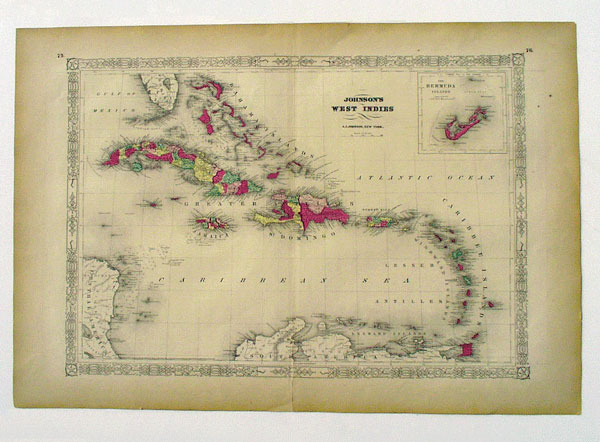
Johnson. West
Indies. 1864. 56x40cms with Bermuda inset 10x10cms. |
|||||||
Keulen, Johannes van (1654 - 1715) Fine chart of Bermuda 1702. |
|||||||
Le Rouge. Bermuda and Jamaica. 26.5x20cms. 1746. Outline colour. Paris. Le Rouge was obviously fascinated by the parish names of the two islands and printed the islands on the same page, with Bermuda getting as much recognition as Jamaica even though it is very much the smaller place. Once again there is that odd little ‘Bermudos’ off North Shore. |
|||||||
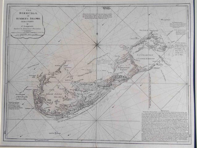
Lempriere, C. 1797 A fine chart of the Bermudas or Summer's Islands from a 1775 survey by Lempriere, but significantly lacking the fresh data discovered by Capt. Thomas Hurd and his team between 1783 and 1797 such as the extent of the reef to the north of our islands. 60 x 45 cm. This map appears in the West India Atlas of Thomas Jeffreys of 1797. Uncoloured. Published in London by Laurie and Whittle. |
|||||||
Lucas, Fielding Jr (1781 - 1854). Elegant separate map of Bermuda. 1823 9 x 11 inches. Original printed colour plate. |
|||||||
Mercator. 1635
23 x 16.50 cms |
|||||||
Military Map. Bermuda. 1880 Drawn by hand. 5 x 10 inches. |
|||||||
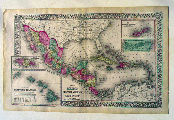
Mitchell. Map of Mexico, Central America and the West Indies. 1871. 55x34cms original colour with decorated borders. Contains an inset of Bermuda 7x12cms, along with Panama, The Sandwich Islands (Hawaii) and Jamaica. Another version 1884 replaces Hawaii with the proposed Nicaragua Canal and a ship railroad through Mexaco. |
|||||||
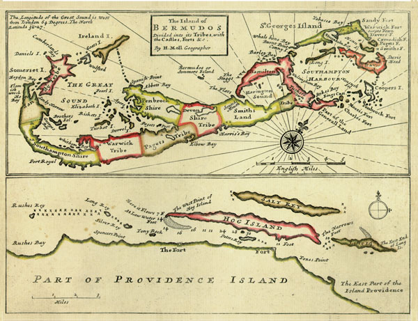
Moll with Part of Providence
Island. 27x20cms. 1727. Outline colour. |
|||||||
Moll, Herman (1678 - 1732). Map of Bermuda and Carolina. 1717 7 x 10 inches. |
|||||||
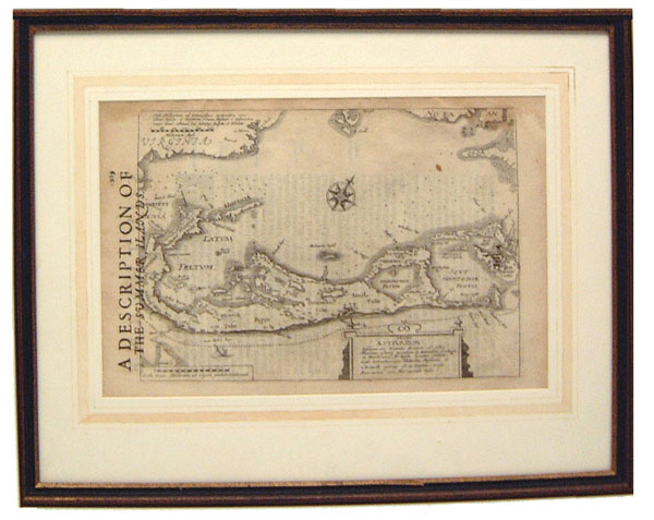
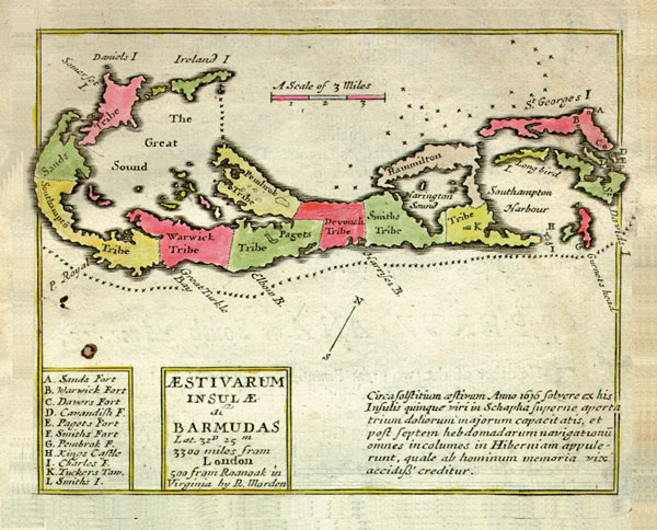
Morden. See under Blome Amerique Anglois among the books, Aestivarum Insulae
al Bermudas. 14x18cms. Uncoloured. 1688. |
|||||||
Ogilby. Barmudas. London. 1670. 35.5x29cms. Hand coloured. Appears in an Accurate Description of the New World by John Ogilby, printed by Thomas Johnson. A most attractive variant on the Norwood survey map, complete with cartouches and vignettes of mermaids, sea monsters, seventeenth century Adventurers with flags and full dress uniform collaborating with Indians in the measuring and charting of the land they conquered. A variation in the watermark on this map was used by Montanus in 1671 and Von Meurs in 1673 in their respective atlases. |
|||||||
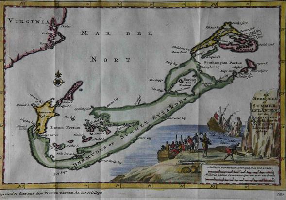
Pieter Van Der Aa. Bermuda and the Sea Venture. Hand coloured. c. 1707. 7 x 6 inches. |
|||||||
Pieter Van Der Aa. Very Rare Bermuda Map. Hand coloured. Strong impression. 14 x 12 inches. 35.5 x 29 cms. In 1729 Pieter Van Der Aa attempted something daring in terms of cartography. He published ‘La Galerie Agreable du Monde’ in Leiden, Netherlands, a set of 66 volumes of beautiful maps of the world. One of these was a totally new illustration of our island, complete with British gentry, American Indian and Black Bermudians surveying and measuring local topography. Only one hundred of these sets – which means 100 of the Bermuda maps – were sold, making this one of the most sort after for a collector. |
|||||||
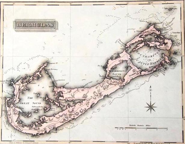
Philip. Bermudas or Somers Islands. 30.5x28cms. Outline colour. c1850. A derivative of the Thomson map of 1817 about which there is reference made later, this is the Bermuda portion only. Philip names all the parishes and decorates his map quite differently from Thomson. |
|||||||
Rand McNally. 60x33cms. The Bermudas or Somers Islands appeared in the Commercial Atlas of America 1916. Full colour. Though the most modern map in the catalogue, the Rand McNally is not without its positive characteristics since it describes Hamilton Long or Bermuda Island and predates the railway or the building of the bases. |
|||||||
Scherer, Heinrich (1628 - 1704). Scarce map of the British Isles, New England and Bermuda. Handcoloured. 9 3/4 x 14 1/2 inches. |
|||||||
Senex. A New Map of the English Empire in the Ocean of America or West Indies. London 1721. 60.5x50.5cms.Outline Colour. Divided into eight irregular compartments, this plate shows six separate islands of which Bermudos forms a decorative portion in the left hand quarter. A well drawn geographical map. |
|||||||
|
|||||||
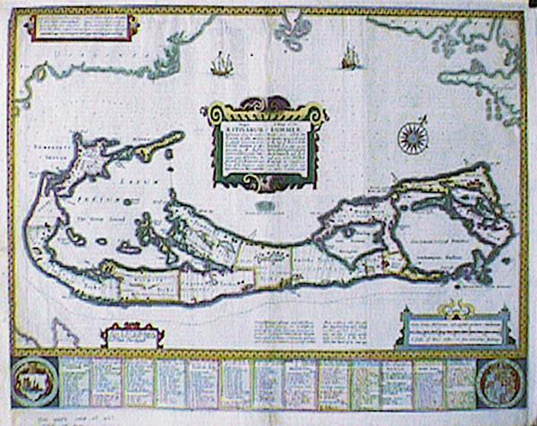
Speed. A Mapp of the Sommer Islands. 53x40cms. Hand coloured. Compiled in 1622 by Norwood, this was the first English map in an atlas to show the Island divided into Tribes and Lots, with the shares of the new Adventurers underneath. It became the standard map of the seventeenth century and was much copied by others. The engraver was Abraham Goos and the edition for sale, the 1676, was to be sold by Thomas Bassett in Fleet street and Richard Chiswell in St Pauls. Please note that Speed’s name never appears on the Bermuda map, only Goos. In other plates in the same atlas-notably some of the English counties his name is engraved. |
|||||||
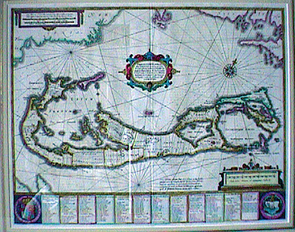
Stanford's Bermuda Map. Published by Gregory V Lee, the editor of the Royal Gazette, 1872. Hamilton, Bermuda. Engraved by Stanford’s Geographical Establishment, London. An unusual and colourful map of Bermuda showing the exciting activities happening on the island in the third quarter of the nineteenth century. There is a large hospital at Dockyard, a horse ferry at Watford bridge, a busy Admiralty Establishment in Pembroke, bustling steam ferry routes, the British Army presence in St Georges, a rapidly growing city in Hamilton. On the wider scale, Bermuda has regular and frequent connections with America, the West Indies and Europe, all clearly indicated on the map. Quite a centre of commerce. |
|||||||
|
Swanston. The West Indies. 1860. Bermuda appears as an inset of 7x7cms in this 53x42cm lithograph, published by A Fullarton and Co of Edinburgh. |
||||||
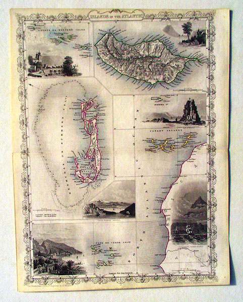
Tallis.Islands in the Atlantic. 22x31cms. c1851. Outline colour. Bermuda occupies the left hand portion of this map of some of the volcanic islands in the Atlantic. Appearing in the Illustrated Atlas and Modern History of the World, published in London, Tallis’ map has always been a favorite with collectors. |
|||||||
Thomson. The Bermudas or Summers Islands (together with The Bahamas and Cuba). 60x50cms. London 1817. Outline colour. Bound into Thomson’s New General Atlas, Bermuda measures 29.5x27.5cms on this map engraved by Neele. Hamilton is shown as the capital and main roads and telegraphs are depicted. A new and innovative piece of cartography for its time. |
|||||||
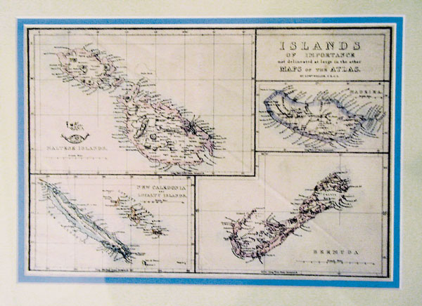
Weller. Islands of Importance. 39x46cms. Chromo-lithograph. 1857. This appeared in the Weekly Dispatch Atlas, 139 Fleet St. London. Bermuda measures 16x11cms and is attractively drawn but with no reef line. |
|||||||
Wells. A New Map of the Most Considerable Plantations of the English in America. 48x35.5 cms. Original colour. 1700. Published and printed in London. |
|||||||
Zatta. Le Isole Bermude. 42x31.5cm. (See front cover of catalogue). Original colour. 1775. This striking Bermuda map has long been sought after by collectors, though on the face of it, besides inaccuracies in the map itself, Zatta seems to have been greatly misinformed about the island’s topography. There are beaver to be seen, Native American huts, exotic birds and a jungle atmosphere. Surely this is not the case on our island. However, when it is realized that the Bermuda map is actually the frontispiece of an Atlas of North America, with us mere ornamentation on the first page, then Zatta’s purpose is clearer. |
|||||||
| Return to Home Page | |||||||


.jpg)